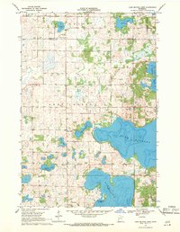
1969 Map of Lake Miltona West
USGS Topo · Published 1971About this map
The glacial landscape of Douglas County, Minnesota, is dominated by the intricate shorelines of major water bodies in this late 1960s survey. The massive Lake Miltona and Lake Ida define the southern and eastern reaches of the sheet, featuring named landmarks such as Betsy Ross Point and Christopherson Bay. These lakes provided the primary geographical anchor for early settlement and seasonal development in the region.
Find a feature on this map
24 named features on this map. Tap any name to fly to it.
Don’t see what you’re looking for? This feature index may not catch every label — zoom into the map to look around manually.
Map Details
Editions of this 1969 Lake Miltona West Map
This is the sole edition of this map. No revisions or reprints were ever made.
Other maps of this area

1953 · Brainerd
USGS Topo · 1:250,000

1953 · Saint Cloud
USGS Topo · 1:250,000

1957 · Brainerd
USGS Topo · 1:250,000

1957 · Saint Cloud
USGS Topo · 1:250,000

1958 · Saint Cloud
USGS Topo · 1:250,000

1958 · Brainerd
USGS Topo · 1:250,000

1965 · Brainerd
USGS Topo · 1:250,000

1966 · Brandon
USGS Topo · 1:24,000

1966 · Alexandria West
USGS Topo · 1:24,000

1966 · Alexandria East
USGS Topo · 1:24,000
Featured Places
- Leaf Valley, MN
- Parkers Prairie Township, MN
- Effington Township, MN
- Otter Tail County, MN
- Douglas County, MN