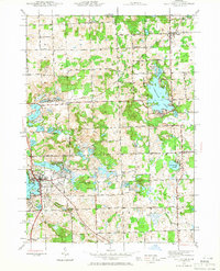
1943 Map of Lake Orion
USGS Topo · Published 1965About this map
Lake Orion serves as the focal point of this 1940s landscape, illustrating a region defined by its complex glacial hydrology and established transport networks. The village of Lake Orion is nestled along the southwestern shore, where the Michigan Central railroad cuts through the terrain. To the north and east, the Grand Trunk Western railroad connects the settlement of Leonard to the broader regional economy. The map reveals a dense distribution of rural infrastructure, including numerous one-room schoolhouses like North Oxford Sch and Kingsbury Sch, alongside local landmarks such as Rudds Mill.
Find a feature on this map
85 named features on this map. Tap any name to fly to it.
Don’t see what you’re looking for? This feature index may not catch every label — zoom into the map to look around manually.
Map Details
Editions of this 1943 Lake Orion Map
2 editions found
Other maps of this area

1907 · Pontiac
USGS Topo · 1:62,500

1908 · Rochester
USGS Topo · 1:62,500

1936 · Rochester
USGS Topo · 1:31,680

1936 · Washington
USGS Topo · 1:31,680

1936 · Pontiac North
USGS Topo · 1:31,680

1943 · Pontiac North
USGS Topo · 1:24,000

1943 · Lake Orion
USGS Topo · 1:24,000

1943 · Oxford
USGS Topo · 1:24,000

1943 · Metamora
USGS Topo · 1:24,000

1943 · Romeo
USGS Topo · 1:24,000
Featured Places
- Orion Charter Township, MI
- Oxford Charter Township, MI
- Oakland Charter Township, MI
- Addison Township, MI
- Oxford, MI