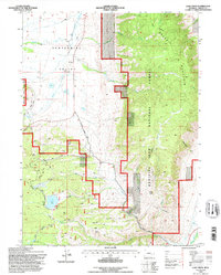
1992 Map of Lake Owen
USGS Topo · Published 1996About this map
Centennial Valley serves as a wide transition between the high peaks of the Medicine Bow National Forest and the lower river basins of Albany County. This 1992 revision, based on surveys from the late 1950s and late 1980s, documents a landscape where water management and transportation infrastructure define the terrain. The Aqueduct system cutting through the valley floor highlights the region's historical reliance on diverted water, while the Union Pacific rail line and Woods Landing Road provide the primary corridors for commerce and transit. Local history is anchored by markers like the Buckeye Sch and family-named landmarks like Iron Mtn. To the east, the dramatic rise of Sheep Mountain is navigated by the Sheep Mountain Trail, looking down over drainage systems such as Moonshine Gulch and Strain Creek that feed toward the Laramie River.
Find a feature on this map
21 named features on this map. Tap any name to fly to it.
Don’t see what you’re looking for? This feature index may not catch every label — zoom into the map to look around manually.
Map Details
Editions of this 1992 Lake Owen Map
This is the sole edition of this map. No revisions or reprints were ever made.
Other maps of this area

1895 · Laramie
USGS Topo · 1:125,000

1902 · Laramie
USGS Topo · 1:125,000

1905 · Laramie
USGS Topo · 1:125,000

1906 · Medicine Bow
USGS Topo · 1:125,000

1906 · Laramie
USGS Topo · 1:125,000

1908 · Laramie
USGS Topo · 1:125,000

1908 · Medicine Bow
USGS Topo · 1:125,000

1954 · Cheyenne
USGS Topo · 1:250,000

1954 · Rawlins
USGS Topo · 1:250,000

1958 · Rawlins
USGS Topo · 1:250,000