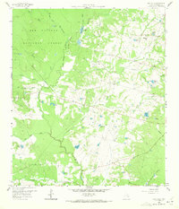
1958 Map of Lake Paula
USGS Topo · Published 1972About this map
The Sam Houston National Forest dominates the northwestern portion of this landscape, its boundary cutting through a region defined by the winding West Fork San Jacinto River and its numerous tributaries. In the late 1950s, this area of Montgomery County was a patchwork of small private lakes and active resource extraction, notably the Willis Oil Field situated near Weirs Creek.
Find a feature on this map
40 named features on this map. Tap any name to fly to it.
Don’t see what you’re looking for? This feature index may not catch every label — zoom into the map to look around manually.
Map Details
Editions of this 1958 Lake Paula Map
3 editions found
Other maps of this area

1954 · Beaumont
USGS Topo · 1:250,000

1957 · Beaumont
USGS Topo · 1:250,000

1958 · Conroe
USGS Topo · 1:24,000

1958 · Cowl Spur
USGS Topo · 1:24,000

1958 · Lake Paula
USGS Topo · 1:24,000

1959 · Moore Grove
USGS Topo · 1:24,000

1959 · San Jacinto
USGS Topo · 1:24,000

1959 · Montgomery
USGS Topo · 1:24,000

1960 · Willis
USGS Topo · 1:24,000

1960 · New Waverly
USGS Topo · 1:24,000