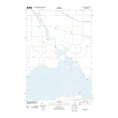
2010 Map of Lake Poygan
USGS Topo · Published 2010About this map
Lake Poygan and the confluence of the Wolf River and Rat River dominate this landscape, where water has long shaped the pattern of settlement. Near the riverbanks, the small community of Orihula sits tucked away, while the hamlet of Zittau serves as a local inland hub. The area is notable for its concentration of early burial grounds, including Wolf River Cemetery, Becker Cemetery, and Saint Pauls Cemetery, reflecting the multi-generational presence of farming families in this part of Winnebago County. The intricate shoreline along the northern reaches of the lake is punctuated by landmarks such as Old Indian Point and Boom Island, illustrating the complex delta-like environment where the river systems meet the open water of the lake. This 2010 survey provides a clear look at the mix of marshland, agriculture, and rural residences that define the region's character.
Find a feature on this map
45 named features on this map. Tap any name to fly to it.
Don’t see what you’re looking for? This feature index may not catch every label — zoom into the map to look around manually.
Map Details
Editions of this 2010 Lake Poygan Map
This is the sole edition of this map. No revisions or reprints were ever made.
Other maps of this area

1955 · Green Bay
USGS Topo · 1:250,000

1956 · New London
USGS Topo · 1:48,000

1956 · Weyauwega
USGS Topo · 1:48,000

1961 · Poy Sippi
USGS Topo · 1:62,500

1961 · Oshkosh
USGS Topo · 1:62,500

1961 · Lake Poygan
USGS Topo · 1:24,000
1961 · Auroraville
USGS Topo · 1:24,000

1961 · Oshkosh NW
USGS Topo · 1:24,000
1961 · Eureka
USGS Topo · 1:24,000
1961 · Omro
USGS Topo · 1:24,000