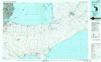
1985 Map of Lake St. Clair South
USGS Topo · Published 1991About this map
The international border between Michigan and Ontario bisects Lake St Clair, separating the heavily developed shorelines of Detroit and Windsor. On the American side, the residential expansion of the Grosse Pointe communities, including Grosse Pointe Woods and Grosse Pointe Park, reaches the edge of Macomb and Wayne counties. Across the Detroit River, the Canadian landscape features a transition from the urban centers of Walkerville and South Walkerville into the agricultural plains of Essex and Kent counties. Significant conservation efforts are visible in the Jack Miner Bird Sanctuary and the St Clair National Wildlife Area. To the north, the complex wetlands of Walpole Island and the Walpole Island Indian Reserve 46 dominate the delta where the St. Clair River enters the lake, while the southern shoreline touches Lake Erie at points like Belle Point.
Find a feature on this map
187 named features on this map. Tap any name to fly to it.
Don’t see what you’re looking for? This feature index may not catch every label — zoom into the map to look around manually.
Map Details
Editions of this 1985 Lake St. Clair South Map
2 editions found
Other maps of this area

1905 · Detroit
USGS Topo · 1:62,500

1905 · Grosse Pointe
USGS Topo · 1:62,500

1906 · Wyandotte
USGS Topo · 1:62,500

1908 · Rochester
USGS Topo · 1:62,500

1912 · Mt Clemens
USGS Topo · 1:62,500

1912 · Wyandotte
USGS Topo · 1:62,500

1914 · Algonac
USGS Topo · 1:62,500

1918 · Detroit
USGS Topo · 1:62,500

1918 · Grosse Pointe
USGS Topo · 1:62,500

1924 · Detroit
USGS Topo · 1:62,500