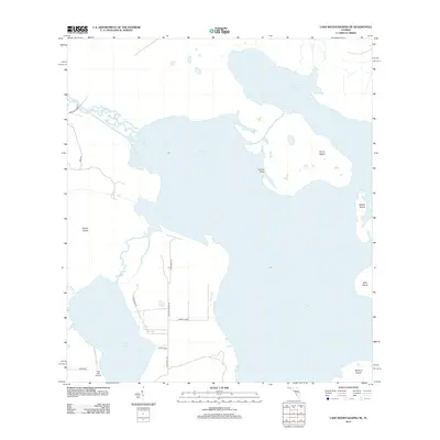
2012 Map of Lake Weohyakapka NE
USGS Topo · Published 2012About this map
Lake Kissimmee dominates the center of this 2012 survey, its expansive waters interrupted by several prominent landmasses including Sturm Island, Rabbit Island, and Bird Island. The map illustrates a transitional landscape where the central Florida wetlands meet sparse residential and recreational development. To the southwest, Tiger Lake is connected by winding waterways and bordered by Tiger Lake Airport. The terrestrial portions of the quadrangle are marked by localized landing spots and camps, such as Thomas Lndg and Camp Tiger, which suggest a culture deeply tied to the lake's resources and sportsmanship. Access to the shoreline is provided by a network of rural routes like Sam Keen Rd and Lightsey Ranch Rd, which weave between the western marshes of Rosalie Cr and the larger lakefront points.
Find a feature on this map
19 named features on this map. Tap any name to fly to it.
Don’t see what you’re looking for? This feature index may not catch every label — zoom into the map to look around manually.
Map Details
Editions of this 2012 Lake Weohyakapka NE Map
This is the sole edition of this map. No revisions or reprints were ever made.
Other maps of this area

1952 · Lake Weohyakapka SE
USGS Topo · 1:24,000

1952 · Lake Weohyakapka NE
USGS Topo · 1:24,000

1952 · Hesperides
USGS Topo · 1:24,000

1952 · Lake Weohyakapka
USGS Topo · 1:24,000

1953 · Lake Marian NW
USGS Topo · 1:24,000

1953 · Cypress Lake
USGS Topo · 1:24,000

1953 · Lake Marian SW
USGS Topo · 1:24,000

1953 · Lake Hatchineha
USGS Topo · 1:24,000

1953 · Holopaw SW
USGS Topo · 1:24,000

1955 · Orlando
USGS Topo · 1:250,000