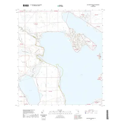
2021 Map of Lake Weohyakapka NE
USGS Topo · Published 2021About this map
Lake Kissimmee dominates this central Florida landscape, where the waters of the Kissimmee River connect a network of marshes and large islands. The boundary between Osceola County and Polk County runs through the northern reaches of the lake, cutting past Sturm Island and Lemon Point. Along the western shore, the Lake Kissimmee State Park Trail system provides access to the shoreline, while the interior is marked by cattle ranching infrastructure, evidenced by Lightsey Ranch Rd. To the south, Tiger Lake is serviced by the Tiger Lake Airport, a small landing strip located near Rawls Rd. The map details a transition from open water to complex wetlands, including Cobb Marsh and Otter Slough, illustrating the enduring hydrologic patterns of the region before further modern development.
Find a feature on this map
31 named features on this map. Tap any name to fly to it.
Don’t see what you’re looking for? This feature index may not catch every label — zoom into the map to look around manually.
Map Details
Editions of this 2021 Lake Weohyakapka NE Map
This is the sole edition of this map. No revisions or reprints were ever made.
Other maps of this area

1952 · Lake Weohyakapka SE
USGS Topo · 1:24,000

1952 · Lake Weohyakapka NE
USGS Topo · 1:24,000

1952 · Hesperides
USGS Topo · 1:24,000

1952 · Lake Weohyakapka
USGS Topo · 1:24,000

1953 · Lake Marian NW
USGS Topo · 1:24,000

1953 · Cypress Lake
USGS Topo · 1:24,000

1953 · Lake Marian SW
USGS Topo · 1:24,000

1953 · Lake Hatchineha
USGS Topo · 1:24,000

1953 · Holopaw SW
USGS Topo · 1:24,000

1955 · Orlando
USGS Topo · 1:250,000