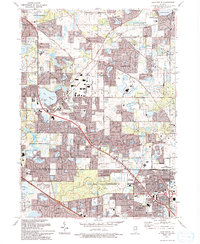
1993 Map of Lake Zurich
USGS Topo · Published 1993About this map
The northern Lake-Cook county border area exhibits a landscape of rapid suburban development and established villages in the early 1990s. Surrounding the prominent Lake Zurich shoreline, residential expansion presses against numerous schools and religious sites, such as the Whitney Sch and Alpine Chapel. This survey captures the transition of former rural tracts into the structured neighborhoods of Kildeer, Deer Park, and Long Grove. Local history is anchored by several burial grounds including Fairfield Cem and Sutherland Cem, while the Mt St Joseph Childrens Home stands as a significant institutional landmark. Drainage through Buffalo Creek and Indian Creek provides natural buffers between housing developments and the expansive County Forest Preserve, highlighting the regional planning effort to balance growth with protected green space.
Find a feature on this map
74 named features on this map. Tap any name to fly to it.
Don’t see what you’re looking for? This feature index may not catch every label — zoom into the map to look around manually.
Map Details
Editions of this 1993 Lake Zurich Map
2 editions found
Other maps of this area

1900 · Highwood
USGS Topo · 1:62,500

1906 · Waukegan
USGS Topo · 1:62,500

1908 · Waukegan
USGS Topo · 1:62,500

1920 · Grays Lake
USGS Topo · 1:62,500

1923 · Grays Lake
USGS Topo · 1:62,500

1923 · Barrington
USGS Topo · 1:62,500

1927 · Arlington Heights
USGS Topo · 1:24,000

1928 · Wheeling
USGS Topo · 1:24,000

1935 · Barrington
USGS Topo · 1:62,500
1953 · Arlington Heights
USGS Topo · 1:24,000