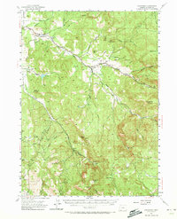
1954 Map of Lakecreek
USGS Topo · Published 1973About this map
Little Butte Creek and its complex network of forks and irrigation works define the agricultural and hydraulic character of this Jackson County landscape in the mid-1950s. The settlement of Lakecreek serves as a central point where the North Fork and South Fork converge, supported by engineered water systems like the Medford Irrigation District Canal. Evidence of early 20th-century water management is visible through specific engineering landmarks, including the Yankee Creek Siphon and the Bradshaw Drop.
Find a feature on this map
40 named features on this map. Tap any name to fly to it.
Don’t see what you’re looking for? This feature index may not catch every label — zoom into the map to look around manually.
Map Details
Editions of this 1954 Lakecreek Map
3 editions found
Other maps of this area

1891 · Ashland
USGS Topo · 1:250,000

1893 · Ashland
USGS Topo · 1:250,000

1897 · Ashland
USGS Topo · 1:250,000

1938 · Medford
USGS Topo · 1:125,000

1943 · Trail
USGS Topo · 1:62,500

1954 · Medford
USGS Topo · 1:62,500

1954 · Butte Falls
USGS Topo · 1:62,500

1954 · Lakecreek
USGS Topo · 1:62,500

1954 · Talent
USGS Topo · 1:62,500

1954 · Ashland
USGS Topo · 1:62,500