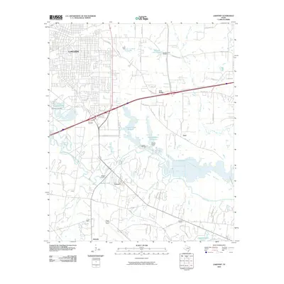
2010 Map of Lakeport
USGS Topo · Published 2010About this map
Longview expands toward the southeast in this 2010 topographic record, where the industrial and residential grid meets the winding course of the Sabine River. The landscape is defined by a series of significant water management structures and reservoirs, including the Ferguson Creek Reservoir, Tanyard Branch Reservoir, and Lake Letourneau, each supported by its respective named dam. These water bodies, along with the Sabine River floodplains, create a complex drainage network involving Massey Branch and Mason Creek.
Find a feature on this map
62 named features on this map. Tap any name to fly to it.
Don’t see what you’re looking for? This feature index may not catch every label — zoom into the map to look around manually.
Map Details
Editions of this 2010 Lakeport Map
This is the sole edition of this map. No revisions or reprints were ever made.
Other maps of this area

1936 · Kilgore
USGS Topo · 1:48,000

1940 · Kilgore
USGS Topo · 1:62,500

1956 · Tyler
USGS Topo · 1:250,000

1958 · Tatum
USGS Topo · 1:62,500

1960 · White Oak
USGS Topo · 1:24,000

1961 · Hallsville
USGS Topo · 1:24,000

1962 · Longview Heights
USGS Topo · 1:24,000

1971 · Kilgore NE
USGS Topo · 1:24,000
1971 · Kilgore SE
USGS Topo · 1:24,000

1983 · Tatum
USGS Topo · 1:24,000