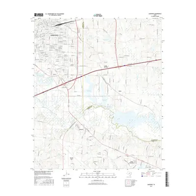
2016 Map of Lakeport
USGS Topo · Published 2016About this map
Longview dominates the northwestern corner of this East Texas survey, where residential streets like Oakdale Ave and Ridgelea Ave extend toward the eastern industrial and educational corridors. The presence of LeTourneau Univ marks a significant institutional footprint just north of where the landscape transitions into the river bottomlands. The Sabine River carves a meandering path through the center of the sheet, creating a wide riparian zone filled with wetlands and smaller water bodies such as Mitchell Lake and Lutes Lake.
Find a feature on this map
189 named features on this map. Tap any name to fly to it.
Don’t see what you’re looking for? This feature index may not catch every label — zoom into the map to look around manually.
Map Details
Editions of this 2016 Lakeport Map
This is the sole edition of this map. No revisions or reprints were ever made.
Other maps of this area

1936 · Kilgore
USGS Topo · 1:48,000

1940 · Kilgore
USGS Topo · 1:62,500

1956 · Tyler
USGS Topo · 1:250,000

1958 · Tatum
USGS Topo · 1:62,500

1960 · White Oak
USGS Topo · 1:24,000

1961 · Hallsville
USGS Topo · 1:24,000

1962 · Longview Heights
USGS Topo · 1:24,000

1971 · Kilgore NE
USGS Topo · 1:24,000
1971 · Kilgore SE
USGS Topo · 1:24,000

1983 · Tatum
USGS Topo · 1:24,000