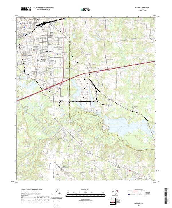
2022 Map of Lakeport
USGS Topo · Published 2022About this map
The Sabine River cuts through this East Texas landscape, forming a natural boundary between the city of Longview and the surrounding rural communities of Lakeport and Estes. In the north, the urban grid of Longview is anchored by the Gregg County Courthouse and the extensive campus of LeTourneau University. Moving south across the river, the landscape transitions into a network of tributaries like Massey Br and Peatown Br that drain into Mitchell Lake and Lutes Lake.
Find a feature on this map
123 named features on this map. Tap any name to fly to it.
Don’t see what you’re looking for? This feature index may not catch every label — zoom into the map to look around manually.
Map Details
Editions of this 2022 Lakeport Map
This is the sole edition of this map. No revisions or reprints were ever made.
Other maps of this area

1936 · Kilgore
USGS Topo · 1:48,000

1940 · Kilgore
USGS Topo · 1:62,500

1956 · Tyler
USGS Topo · 1:250,000

1958 · Tatum
USGS Topo · 1:62,500

1960 · White Oak
USGS Topo · 1:24,000

1961 · Hallsville
USGS Topo · 1:24,000

1962 · Longview Heights
USGS Topo · 1:24,000

1971 · Kilgore NE
USGS Topo · 1:24,000
1971 · Kilgore SE
USGS Topo · 1:24,000

1983 · Tatum
USGS Topo · 1:24,000