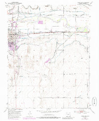
1953 Map of Lamar East
USGS Topo · Published 1985About this map
The Arkansas River corridor in Prowers County is defined by an intricate network of irrigation and transport, including the historic path of the Old Santa Fe Trail. The eastern reaches of Lamar showcase a landscape shaped by water management, with the Amity Canal, Hyde Canal, and Vista Del Rio Ditch providing the vital infrastructure for high-plains agriculture. This mid-century survey captures the settlement pattern established by the Atchison Topeka and Santa Fe railroad, which parallels the river and connects small sidings and communities like Clucas and Markham. Local history is deeply etched into the terrain through several burial grounds, including Riverside Cemetery, Fairmount Cemetery, and Mt Olive Cem. From the Southeast Colorado Fairgrounds to the secluded Clay Creek School, the map documents the civic and educational centers of a rural Colorado community at a point of steady mid-century growth.
Find a feature on this map
39 named features on this map. Tap any name to fly to it.
Don’t see what you’re looking for? This feature index may not catch every label — zoom into the map to look around manually.
Map Details
Editions of this 1953 Lamar East Map
5 editions found

Other maps of this area

1890 · Granada
USGS Topo · 1:125,000

1891 · Albany
USGS Topo · 1:125,000

1892 · Lamar
USGS Topo · 1:125,000

1892 · Granada
USGS Topo · 1:125,000

1892 · Two Butte
USGS Topo · 1:125,000

1893 · Two Butte
USGS Topo · 1:125,000

1893 · Albany
USGS Topo · 1:125,000

1894 · Granada
USGS Topo · 1:125,000

1952 · Lamar West
USGS Topo · 1:24,000

1952 · Carlton
USGS Topo · 1:24,000