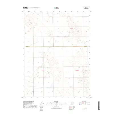
2017 Map of Lamar NE
USGS Topo · Published 2017About this map
The rolling plains along the Perkins Co Chase Co border are defined by a grid of rural section lines and the seasonal course of Spring Cr. This landscape in southwest Nebraska, near the Colorado border, reflects the agricultural organization of the High Plains, where remote airstrips like Hendricks Field serve as vital infrastructure for local aviation and crop management. The area is intersected by a network of county roads, including Co Rd 753 and 322 Ave, which delineate the vast township and range divisions of T9N and T8N. The topography is marked by subtle depressions and the characteristic drainages of the semi-arid West, showing the spatial layout of modern farming and ranching before the encroachment of denser development.
Find a feature on this map
18 named features on this map. Tap any name to fly to it.
Don’t see what you’re looking for? This feature index may not catch every label — zoom into the map to look around manually.
Map Details
Editions of this 2017 Lamar NE Map
This is the sole edition of this map. No revisions or reprints were ever made.
Other maps of this area

1954 · McCook
USGS Topo · 1:250,000

1957 · McCook
USGS Topo · 1:250,000

1958 · McCook
USGS Topo · 1:250,000

1961 · Lamar NE
USGS Topo · 1:24,000

1961 · Lamar
USGS Topo · 1:24,000

1961 · Brandon SE
USGS Topo · 1:24,000

1961 · Lamar NW
USGS Topo · 1:24,000

1961 · Brandon
USGS Topo · 1:24,000
1973 · Lamar
USGS Topo · 1:24,000
1973 · Chase
USGS Topo · 1:24,000