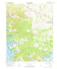
1967 Map of Lamasco
USGS Topo · Published 1968About this map
Lake Barkley dominates the western and southern landscape of this 1967 survey, where the Cumberland River and Little River have been transformed into a wide reservoir system. The shoreline is punctuated by emerging developments like Blue Water Estates and Rockcastle Shores, though the interior terrain remains dense with genealogical markers. Dozens of family-named burial grounds, including the Stephens Cem, Piercy Cem, and Wynn Cem, are scattered across the ridges between Shelly Creek and Hurricane Creek. These sites, along with the Hurricane Ch and Siloam Ch, provide a clear record of the rural communities established long before the flooding of the valley. The map also captures infrastructure in transition, notably the Proposed Location of a major roadway cutting across the northern reaches near Lamasco.
Find a feature on this map
58 named features on this map. Tap any name to fly to it.
Don’t see what you’re looking for? This feature index may not catch every label — zoom into the map to look around manually.
Map Details
Editions of this 1967 Lamasco Map
2 editions found
Other maps of this area

1908 · Princeton
USGS Topo · 1:62,500

1910 · Princeton
USGS Topo · 1:62,500

1928 · Eddyville
USGS Topo · 1:48,000

1931 · Eddyville
USGS Topo · 1:62,500

1936 · Eddyville
USGS Topo · 1:48,000

1936 · Mont
USGS Topo · 1:24,000

1936 · Fenton
USGS Topo · 1:24,000

1936 · Golden Pond
USGS Topo · 1:48,000

1949 · Paducah
USGS Topo · 1:250,000

1950 · Paducah
USGS Topo · 1:250,000