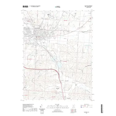
2019 Map of Lancaster
USGS Topo · Published 2019About this map
Lancaster serves as the regional hub of Fairfield County, where the historic street grid meets the winding course of the Hocking River. The terrain is characterized by prominent elevations such as Waterworks Hill and Mt Pleasant, which overlook a landscape dotted with numerous rural burial grounds and educational institutions like the Ohio University - Lancaster Campus. To the south, the valley opens toward Sugar Grove, following the riparian corridor through Horns Mill.
Find a feature on this map
190 named features on this map. Tap any name to fly to it.
Don’t see what you’re looking for? This feature index may not catch every label — zoom into the map to look around manually.
Map Details
Editions of this 2019 Lancaster Map
This is the sole edition of this map. No revisions or reprints were ever made.
Other maps of this area

1907 · Logan
USGS Topo · 1:62,500

1907 · Lancaster
USGS Topo · 1:62,500

1907 · Thurston
USGS Topo · 1:62,500

1909 · Thornville
USGS Topo · 1:62,500

1909 · Lancaster
USGS Topo · 1:62,500

1909 · Logan
USGS Topo · 1:62,500

1909 · Thurston
USGS Topo · 1:62,500

1947 · Columbus
USGS Topo · 1:250,000

1958 · Carroll
USGS Topo · 1:24,000
1958 · Amanda
USGS Topo · 1:24,000