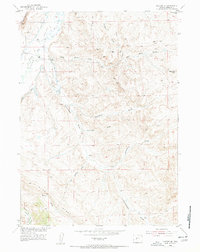
1952 Map of Lander SE
USGS Topo · Published 1956About this map
The Little Popo Agie River carves through the northwest corner of this Fremont County landscape, defining the fertile stretch known as Lyons Valley. Settlement patterns in the early 1950s remained sparse, anchored by the Hall Ranch near the river and the locality of Brynt to the south. An Old Railroad Grade traces a path through the northern hills, a vestige of earlier industrial efforts that once served local coal interests like the Coal Mine and Williams Mine. The rugged topography is characterized by deep erosional features such as Fivemile Draw and Hudson Draw, which cut toward the river from the high country of Blue Ridge. This 1952 field-checked survey captures a transitional moment for the region's agricultural and mining infrastructure, including irrigation works like the Millard Ditch.
Find a feature on this map
20 named features on this map. Tap any name to fly to it.
Don’t see what you’re looking for? This feature index may not catch every label — zoom into the map to look around manually.
Map Details
Editions of this 1952 Lander SE Map
5 editions found
Other maps of this area

1952 · Hudson
USGS Topo · 1:24,000

1952 · Lander SE
USGS Topo · 1:24,000

1952 · Lander
USGS Topo · 1:24,000

1952 · Lander NW
USGS Topo · 1:24,000

1953 · Ninemile Hill
USGS Topo · 1:24,000

1953 · Arapahoe
USGS Topo · 1:24,000

1953 · Del Monte Ridge
USGS Topo · 1:24,000

1953 · Weiser Pass
USGS Topo · 1:24,000

1954 · Wolf Point
USGS Topo · 1:24,000

1955 · Lander
USGS Topo · 1:250,000