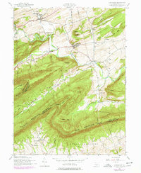
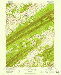
1952 Map of Landisburg
USGS Topo · Published 1978About this map
Loysville and Landisburg serve as the primary hubs in this Perry County landscape, which transitions from the agricultural valleys of Tyrone and Northeast Madison to the prominent ridges of Blue Mountain. The map details a community deeply rooted in its local institutions, from the Tressler Orphan Home in the north to the Hidden Valley Boy Scout Camp along the winding Sherman Creek. This mid-century view captures the area as it stood before significant modern development, preserving the locations of rural schoolhouses like the Spring Dale Sch and Oak Grove School. An Old Railroad Grade north of Loysville hints at former industrial connections, while a network of cemeteries and country churches, such as Mount Zion Church and the McClures Gap Cemetery, provides essential data for genealogical research across the Cumberland and Perry County border.
Find a feature on this map
61 named features on this map. Tap any name to fly to it.
Don’t see what you’re looking for? This feature index may not catch every label — zoom into the map to look around manually.
Map Details
Editions of this 1952 Landisburg Map
4 editions found
Other maps of this area

1904 · Carlisle
USGS Topo · 1:62,500

1907 · New Bloomfield
USGS Topo · 1:62,500

1919 · Newville
USGS Topo · 1:62,500

1930 · Loysville
USGS Topo · 1:62,500

1933 · Loysville
USGS Topo · 1:62,500

1943 · New Bloomfield
USGS Topo · 1:62,500

1943 · Carlisle
USGS Topo · 1:62,500

1945 · Newville
USGS Topo · 1:62,500

1950 · Harrisburg
USGS Topo · 1:250,000
1952 · Spruce Hill
USGS Topo · 1:24,000
Featured Places
- Saville Township, PA
- Landisburg, PA
- Loysville, Tyrone Township
- Bridgeport, Spring Township
- Northeast Madison Township, PA