
1957 Map of Lane NW
USGS Topo · Published 1958About this map
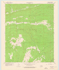
State Game Refuge lands dominate the center of this 1957 study of southeastern Oklahoma, revealing a landscape defined by sharp ridges and deep hollows. The settlement of Fugate sits along the southern edge of the refuge, while local education is anchored by Armstrong Sch and Miller Sch. The drainage patterns of Potapo Creek and Chickasaw Creek illustrate the complex watershed of Atoka County, carving through features like Peacock Hollow and Kennedy Hollow.
Find a feature on this map
28 named features on this map. Tap any name to fly to it.
Don’t see what you’re looking for? This feature index may not catch every label — zoom into the map to look around manually.
Map Details
Editions of this 1957 Lane NW Map
2 editions found
Other maps of this area

1896 · Coalgate
USGS Topo · 1:125,000

1898 · McAlester
USGS Topo · 1:125,000

1899 · Coalgate
USGS Topo · 1:125,000

1899 · Atoka
USGS Topo · 1:125,000

1900 · Atoka
USGS Topo · 1:125,000

1900 · Coalgate
USGS Topo · 1:125,000

1901 · Antlers
USGS Topo · 1:125,000

1909 · Mc Alester
USGS Topo · 1:125,000

1912 · Antlers
USGS Topo · 1:125,000

1925 · Antlers
USGS Topo · 1:125,000