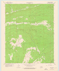
1957 Map of Lane NW
USGS Topo · Published 1976About this map
The State Game Refuge dominates the rugged timberlands of Atoka County in the late 1950s, preserving a vast corridor of Oklahoma's native landscape. This terrain is characterized by a series of prominent drainage systems including Chickasaw Creek, Potapo Creek, and the winding McGee Creek near Horseshoe Bend. Distinctive open spaces such as Hiawana Prairie, West Windy Prairie, and Hickory Flat interrupt the forested hills, suggesting the varied ecology of the Choctaw Country before modern development. Evidence of rural life is sparse but significant for local history, with the small settlement of Fugate and educational outposts like Armstrong Sch and Miller Sch serving the scattered population. The map also captures specific local landmarks such as Texas Hole and numerous named hollows, including Whisky Hollow and Peacock Hollow, which reflect the vernacular geography used by generations of residents.
Find a feature on this map
39 named features on this map. Tap any name to fly to it.
Don’t see what you’re looking for? This feature index may not catch every label — zoom into the map to look around manually.
Map Details
Editions of this 1957 Lane NW Map
2 editions found

Other maps of this area

1896 · Coalgate
USGS Topo · 1:125,000

1898 · McAlester
USGS Topo · 1:125,000

1899 · Coalgate
USGS Topo · 1:125,000

1899 · Atoka
USGS Topo · 1:125,000

1900 · Atoka
USGS Topo · 1:125,000

1900 · Coalgate
USGS Topo · 1:125,000

1901 · Antlers
USGS Topo · 1:125,000

1909 · Mc Alester
USGS Topo · 1:125,000

1912 · Antlers
USGS Topo · 1:125,000

1925 · Antlers
USGS Topo · 1:125,000