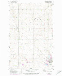
1970 Map of Langdon West
USGS Topo · Published 1984About this map
Dresden and Langdon serve as the primary anchors for this Cavalier County landscape, where the agricultural grid is intersected by the diagonal path of the Burlington Northern railroad. The terrain is defined by the winding course of the South Little Pembina River and numerous depressions typical of the regional prairie pothole topography. Local aviation is represented by two distinct sites: Robertson Field near the southern edge and the more rustic Walts Air Service Landing Strip further west.
Find a feature on this map
23 named features on this map. Tap any name to fly to it.
Don’t see what you’re looking for? This feature index may not catch every label — zoom into the map to look around manually.
Map Details
Editions of this 1970 Langdon West Map
2 editions found
Other maps of this area

1953 · Devils Lake
USGS Topo · 1:250,000

1956 · Devils Lake
USGS Topo · 1:250,000

1967 · Langdon East
USGS Topo · 1:24,000

1967 · Maida
USGS Topo · 1:24,000

1970 · Mount Carmel
USGS Topo · 1:24,000

1970 · Wales
USGS Topo · 1:24,000

1970 · Loma
USGS Topo · 1:24,000

1970 · Hannah SE
USGS Topo · 1:24,000

1970 · Langdon West
USGS Topo · 1:24,000

1972 · Easby
USGS Topo · 1:24,000