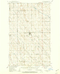
1948 Map of Lansford
USGS Topo · Published 1960About this map
The agrarian plains of the Renville and Bottineau county border are centered on the hub of Lansford, as they appeared during the late 1940s. This survey, conducted as part of the Missouri River Basin development program, illustrates a landscape dominated by a network of rural schoolhouses such as Blaine Sch and Graham Sch, alongside quiet communities like Truro and Forfar. The region's transport is anchored by the Great Northern and Sault Ste Marie And Northern railroads, which facilitated the movement of grain and goods through this northern prairie. Waterways like Spring Coulee, Deep Creek, and Cut Bank Creek cut through the sections, providing essential drainage in a region where the topography was meticulously recorded by plane-table methods. Local heritage is further grounded by the presence of Lansford Cem and St Johns Cem, alongside several industrial sites such as a Gravel Pit.
Find a feature on this map
20 named features on this map. Tap any name to fly to it.
Don’t see what you’re looking for? This feature index may not catch every label — zoom into the map to look around manually.
Map Details
Editions of this 1948 Lansford Map
3 editions found
Other maps of this area

1948 · Dokken SW
USGS Topo · 1:24,000

1948 · Mohall
USGS Topo · 1:24,000

1948 · Lansford
USGS Topo · 1:62,500

1948 · Burlington
USGS Topo · 1:62,500

1948 · Lansford SW
USGS Topo · 1:24,000

1949 · Burlington NW
USGS Topo · 1:24,000

1949 · Glenburn
USGS Topo · 1:24,000

1949 · Lansford NW
USGS Topo · 1:24,000

1949 · Lansford SW
USGS Topo · 1:24,000

1949 · Deering NW
USGS Topo · 1:24,000