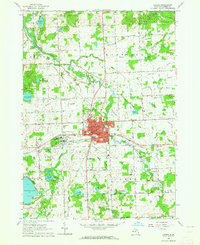
1963 Map of Lapeer
USGS Topo · Published 1964About this map
Lapeer serves as a central hub in this early 1960s survey, showing a landscape defined by significant public institutions and a dense network of country schools. The extensive grounds of the Lapeer State Home and Training School dominate the western edge of the city, while the Dupont Lapeer Airport and a Drive-in Theater highlight the mid-century infrastructure. To the north, the Lapeer State Game Area preserves the wetland terrain near McKeen Lake and Grass Lake.
Find a feature on this map
111 named features on this map. Tap any name to fly to it.
Don’t see what you’re looking for? This feature index may not catch every label — zoom into the map to look around manually.
Map Details
Editions of this 1963 Lapeer Map
2 editions found
Other maps of this area

1943 · Metamora
USGS Topo · 1:24,000

1945 · Thornville
USGS Topo · 1:24,000

1945 · Hadley
USGS Topo · 1:24,000

1946 · Metamora
USGS Topo · 1:24,000

1954 · Detroit
USGS Topo · 1:250,000

1954 · Flint
USGS Topo · 1:250,000

1958 · Flint
USGS Topo · 1:250,000

1961 · Detroit
USGS Topo · 1:250,000

1963 · Attica
USGS Topo · 1:24,000

1963 · North Branch
USGS Topo · 1:24,000