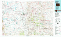
1981 Map of Laramie
USGS Topo · Published 1981About this map
Laramie sits as the central hub of this 1981 survey, where the Univ of Wyoming and General Brees Field mark the city's growth. The surrounding landscape transitions from the open Laramie Valley and the massive depression of Big Hollow to the east, where the Laramie Mountains and Medicine Bow National Forest rise toward Sherman Hill. This period shows the heavy reliance on the Union Pacific rail corridor, which threads through mountain passes and small high-plains settlements like Hermosa and Tie Siding.
Find a feature on this map
89 named features on this map. Tap any name to fly to it.
Don’t see what you’re looking for? This feature index may not catch every label — zoom into the map to look around manually.
Map Details
Editions of this 1981 Laramie Map
2 editions found
Other maps of this area

1895 · Laramie
USGS Topo · 1:125,000

1902 · Laramie
USGS Topo · 1:125,000

1905 · Sherman
USGS Topo · 1:125,000

1905 · Laramie
USGS Topo · 1:125,000

1906 · Medicine Bow
USGS Topo · 1:125,000

1906 · Laramie
USGS Topo · 1:125,000

1907 · Livermore
USGS Topo · 1:125,000

1908 · Laramie
USGS Topo · 1:125,000

1908 · Medicine Bow
USGS Topo · 1:125,000

1908 · Eaton
USGS Topo · 1:125,000