
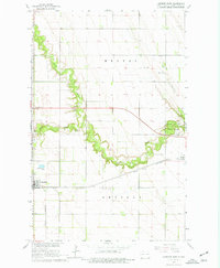
1963 Map of Larimore East
USGS Topo · Published 1964About this map
The Great Northern railroad tracks anchor the southern half of this Grand Forks County landscape, connecting the agricultural hub of Larimore to the smaller settlement of Arvilla. Between these points, the prairie is deeply incised by the Turtle River, which winds eastward through the terrain. The river's path is particularly distinctive where the North Branch and South Branch converge, creating a verdant corridor that stands in stark contrast to the surrounding section-line grid. This natural drainage pattern dictated the location of local recreation and preservation, most notably the Turtle River State Park in the east. Local history is evidenced by the Bellevue Cem west of the river and a Townhall located in the township of Hegton. The map reflects a mid-century rural economy where traditional farming coincided with the development of modern infrastructure like the Sewage Disposal Ponds near the Larimore town limits.
Find a feature on this map
17 named features on this map. Tap any name to fly to it.
Don’t see what you’re looking for? This feature index may not catch every label — zoom into the map to look around manually.
Map Details
Editions of this 1963 Larimore East Map
2 editions found
Other maps of this area

1926 · Ardoch
USGS Topo · 1:62,500

1934 · Emerado
USGS Topo · 1:48,000

1936 · Emerado
USGS Topo · 1:62,500

1936 · Larimore
USGS Topo · 1:62,500

1952 · Grand Forks
USGS Topo · 1:250,000

1952 · Thief River Falls
USGS Topo · 1:250,000

1956 · Thief River Falls
USGS Topo · 1:250,000

1956 · Grand Forks
USGS Topo · 1:250,000

1957 · Thief River Falls
USGS Topo · 1:250,000

1963 · Orr
USGS Topo · 1:24,000