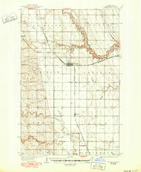
1936 Map of Larimore
USGS Topo · Published 1950About this map
Larimore and the surrounding prairies of Grand Forks County are captured here in the mid-1930s, showing a landscape defined by its grid-iron agriculture and the critical influence of the Great Northern railroad. The railway is the spine of the region, connecting the grain-handling centers at Arvilla, Kempton, and the junction at Hannah Junc. This era shows a dense network of local education, with numerous numbered schoolhouses such as School No 111 and School No 87 situated at regular intervals to serve the rural farm families of Elm Grove and Arvilla townships.
Find a feature on this map
35 named features on this map. Tap any name to fly to it.
Don’t see what you’re looking for? This feature index may not catch every label — zoom into the map to look around manually.
Map Details
Editions of this 1936 Larimore Map
3 editions found
Other maps of this area

1926 · Ardoch
USGS Topo · 1:62,500

1934 · Emerado
USGS Topo · 1:48,000

1936 · Emerado
USGS Topo · 1:62,500

1936 · Larimore
USGS Topo · 1:62,500

1939 · Niagara
USGS Topo · 1:62,500

1952 · Grand Forks
USGS Topo · 1:250,000

1952 · Thief River Falls
USGS Topo · 1:250,000

1956 · Thief River Falls
USGS Topo · 1:250,000

1956 · Grand Forks
USGS Topo · 1:250,000

1957 · Thief River Falls
USGS Topo · 1:250,000