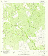
1974 Map of Las Vegas
USGS Topo · Published 1977About this map
Missouri Pacific rails strike a straight diagonal through this South Texas brush country, connecting the small siding of Las Vegas to the surrounding ranchlands. The landscape is defined by the ephemeral drainages of Espio Creek, Elm Creek, and Skull Creek, which carve subtle topography across the County Line between Dimmit and La Salle counties. This 1974 field-checked survey highlights an era of active resource extraction, evidenced by numerous Oil Wells and a Drill Hole scattered throughout the territory. To the southeast, the name Sage marks a localized point of interest near the railroad, while the broader map reveals a network of unimproved roads and fence lines that suggest the large-scale cattle operations typical of the region. The map provides a precise record of an industrializing landscape where the traditional cattle economy met the mid-century oil boom.
Find a feature on this map
13 named features on this map. Tap any name to fly to it.
Don’t see what you’re looking for? This feature index may not catch every label — zoom into the map to look around manually.
Map Details
Editions of this 1974 Las Vegas Map
This is the sole edition of this map. No revisions or reprints were ever made.
Other maps of this area

1925 · San Roque Lake 1-a
USGS Topo · 1:48,000

1927 · Bart
USGS Topo · 1:62,500

1929 · Cotulla
USGS Topo · 1:125,000

1932 · Valley Wells
USGS Topo · 1:62,500

1939 · Big Wells
USGS Topo · 1:62,500

1940 · Catarina
USGS Topo · 1:62,500

1940 · Artesia Wells
USGS Topo · 1:62,500

1953 · Crystal City
USGS Topo · 1:250,000

1955 · Crystal City
USGS Topo · 1:250,000

1956 · Woodward
USGS Topo · 1:62,500