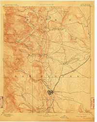
1893 Map of Las Vegas
USGS Topo · Published 1910About this map
The Las Vegas settlement serves as the primary hub of this 1889 survey, where the Atchison Topeka and Santa Fe Railroad cuts through the high plains at the base of the mountains. To the north, Fort Union stands as a significant military and logistical outpost, linked to the surrounding valley by a network of early roads and watercourses like Sapello Creek and the Mora River. The map reveals a landscape defined by traditional Spanish-named settlements and plazas such as La Cueva, Golondrinos, and Peñasco Blanco, reflecting the complex cultural and agricultural history of San Miguel and Mora counties. This reconnaissance work captures the region just as the railroad was transforming local commerce, while older communities like Loma Parda and San Geronimo remained deeply tied to the seasonal flows of the Gallinas Creek and Tecolote Creek.
Find a feature on this map
38 named features on this map. Tap any name to fly to it.
Don’t see what you’re looking for? This feature index may not catch every label — zoom into the map to look around manually.
Map Details
Editions of this 1893 Las Vegas Map
5 editions found
Other maps of this area

1889 · Las Vegas
USGS Topo · 1:125,000

1889 · Santa Fe
USGS Topo · 1:125,000

1890 · Bernal
USGS Topo · 1:125,000

1891 · Bernal
USGS Topo · 1:125,000

1891 · Las Vegas
USGS Topo · 1:125,000

1892 · Watrous
USGS Topo · 1:125,000

1892 · Corazon
USGS Topo · 1:125,000

1893 · Las Vegas
USGS Topo · 1:125,000

1894 · Corazon
USGS Topo · 1:125,000

1894 · Watrous
USGS Topo · 1:125,000