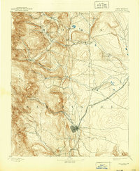
1893 Map of Las Vegas
USGS Topo · Published 1944About this map
Las Vegas serves as the focal point for this 1889 reconnaissance survey, captured at a time when the Atchison Topeka and Santa Fe Railroad was reshaping the commerce of northeastern New Mexico. The map illustrates a landscape transitioning from traditional Hispanic plazas to American territorial outposts, with Fort Union standing at the northeastern edge of the sheet. The settlement pattern follows the life-giving waters of the Mora River, Sapello Creek, and Gallinas Creek, where established communities like La Cueva, Sapello, and San Geronimo are situated at the intersection of steep mountain terrain and open plains. Beyond the rail lines, the topography rises sharply toward the Santa Fe National Forest, dominated by peaks like Solitario Pk and Barrillas Pk. The inclusion of Hot Springs near the city suggests the early development of the region's therapeutic and social hubs.
Find a feature on this map
37 named features on this map. Tap any name to fly to it.
Don’t see what you’re looking for? This feature index may not catch every label — zoom into the map to look around manually.
Map Details
Editions of this 1893 Las Vegas Map
5 editions found
Other maps of this area

1889 · Las Vegas
USGS Topo · 1:125,000

1889 · Santa Fe
USGS Topo · 1:125,000

1890 · Bernal
USGS Topo · 1:125,000

1891 · Bernal
USGS Topo · 1:125,000

1891 · Las Vegas
USGS Topo · 1:125,000

1892 · Watrous
USGS Topo · 1:125,000

1892 · Corazon
USGS Topo · 1:125,000

1893 · Las Vegas
USGS Topo · 1:125,000

1894 · Corazon
USGS Topo · 1:125,000

1894 · Watrous
USGS Topo · 1:125,000