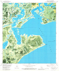
1980 Map of Latania Lake
USGS Topo · Published 1980About this map
Lacassine National Wildlife Refuge dominates the upper-left quadrant of this coastal Louisiana landscape, where the Mermentau River and Bayou Lacassine meet the expansive waters of Grand Lake. The terrain is a complex network of wetlands and hydraulic engineering, defined by the Intracoastal Waterway cutting through Maple Marsh and several man-made channels like Willow Cutoff and Long Cutoff. This 1980 orthophotomap provides a clear view of the industrial footprint in the marsh, highlighting the Lakeside Oil and Gas Field and Grand Lake Oil and Gas Field with their associated sludge pits and pipelines. Prominent land features such as Cypress Ridge, Flat Ridge, and Latania Hill rise above the surrounding water bodies, including Latania Lake and Lake Misere, illustrating the delicate balance of high ground and open water in Cameron Parish.
Find a feature on this map
35 named features on this map. Tap any name to fly to it.
Don’t see what you’re looking for? This feature index may not catch every label — zoom into the map to look around manually.
Map Details
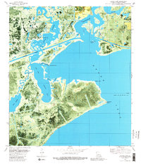
Editions of this 1980 Latania Lake Map
2 editions found
Other maps of this area

1934 · Catfish Lake
USGS Topo · 1:24,000

1934 · Lake Misere
USGS Topo · 1:24,000

1934 · Latania Lake
USGS Topo · 1:24,000

1935 · Lake Misere
USGS Topo · 1:31,680

1935 · Catfish Lake
USGS Topo · 1:31,680

1935 · Latania Lake
USGS Topo · 1:31,680

1935 · Grand Chenier
USGS Topo · 1:31,680

1946 · Lake Arthur
USGS Topo · 1:31,680

1946 · Hayes
USGS Topo · 1:31,680

1947 · Thornwell
USGS Topo · 1:31,680