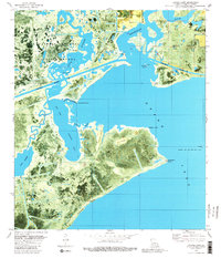
1980 Map of Latania Lake
USGS Topo · Published 1980About this map
The Lacassine National Wildlife Refuge dominates the northwestern reaches of this 1980 orthophotomap, showing a complex network of wetlands where Bayou Lacassine and the Intracoastal Waterway intersect. The landscape is defined by its transition from open water to marshy ridges, with notable elevations like Onion Hill and Latania Hill rising above the surrounding Latania Lake and Mud Lake. This era shows the heavy footprint of energy extraction in Cameron Parish, evidenced by the Lakeside Oil and Gas Field and the Grand Lake Oil and Gas Field with its offshore platforms in Grand Lake. Natural features like Cypress Ridge, Wild Ridge, and Flat Ridge provide a glimpse into the topographical structure of the Louisiana coastline, while man-made cutoffs such as Long Cutoff and Short Cutoff reflect efforts to navigate and manage these tidal waters.
Find a feature on this map
36 named features on this map. Tap any name to fly to it.
Don’t see what you’re looking for? This feature index may not catch every label — zoom into the map to look around manually.
Map Details
Editions of this 1980 Latania Lake Map
2 editions found
Other maps of this area

1934 · Catfish Lake
USGS Topo · 1:24,000

1934 · Lake Misere
USGS Topo · 1:24,000

1934 · Latania Lake
USGS Topo · 1:24,000

1935 · Lake Misere
USGS Topo · 1:31,680

1935 · Catfish Lake
USGS Topo · 1:31,680

1935 · Latania Lake
USGS Topo · 1:31,680

1935 · Grand Chenier
USGS Topo · 1:31,680

1946 · Lake Arthur
USGS Topo · 1:31,680

1946 · Hayes
USGS Topo · 1:31,680

1947 · Thornwell
USGS Topo · 1:31,680