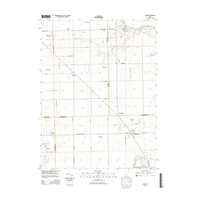
2013 Map of Laura
USGS Topo · Published 2013About this map
Phillipsburg and Laura anchor this corner of the Miami Valley, where the boundaries of Darke, Miami, Preble, and Montgomery counties converge. The landscape is defined by a dense grid of rural roads and agricultural operations, including Spitler Swine Farms and Rench Farm, alongside small village settlements like Potsdam and Midway. The presence of numerous small burial grounds, such as Mote Cem, Ludlow Cem, and Worman Cem, provides significant points of interest for genealogists tracing family histories in these townships.
Find a feature on this map
81 named features on this map. Tap any name to fly to it.
Don’t see what you’re looking for? This feature index may not catch every label — zoom into the map to look around manually.
Map Details
Editions of this 2013 Laura Map
This is the sole edition of this map. No revisions or reprints were ever made.
Other maps of this area

1905 · Brookville
USGS Topo · 1:62,500

1911 · Covington
USGS Topo · 1:62,500

1944 · Covington
USGS Topo · 1:62,500

1953 · Cincinnati
USGS Topo · 1:250,000

1953 · Muncie
USGS Topo · 1:250,000

1955 · West Milton
USGS Topo · 1:24,000
1955 · Trotwood
USGS Topo · 1:24,000

1956 · Muncie
USGS Topo · 1:250,000

1957 · Cincinnati
USGS Topo · 1:250,000

1961 · Laura
USGS Topo · 1:24,000