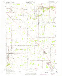
1961 Map of Laura
USGS Topo · Published 1975About this map
Ludlow Creek winds through the northern reaches of this rural landscape, providing a natural focal point for the early 1960s settlements of Laura and Pittsburg. The map reveals a highly structured agricultural grid at the intersection of Darke, Miami, Montgomery, and Preble counties. Transport networks are a primary feature, from the Penn Central rail line running through the northern tier to the numerous family-named roads like Miller Brumbaugh Rd and Wellbaum Rd that suggest long-standing local lineage. Small hamlets like Potsdam, Midway, and Five Points dot the township intersections, reflecting a 19th-century settlement pattern that persisted into the mid-20th century. Local aviation and industry are marked by Myers Airport and a Pumping Sta, while genealogists will find several small burial grounds including Mote Cem and Swank Cem situated among the farmsteads.
Find a feature on this map
59 named features on this map. Tap any name to fly to it.
Don’t see what you’re looking for? This feature index may not catch every label — zoom into the map to look around manually.
Map Details
Editions of this 1961 Laura Map
2 editions found
Other maps of this area

1905 · Brookville
USGS Topo · 1:62,500

1911 · Covington
USGS Topo · 1:62,500

1944 · Covington
USGS Topo · 1:62,500

1953 · Cincinnati
USGS Topo · 1:250,000

1953 · Muncie
USGS Topo · 1:250,000

1955 · West Milton
USGS Topo · 1:24,000
1955 · Trotwood
USGS Topo · 1:24,000

1956 · Muncie
USGS Topo · 1:250,000

1957 · Cincinnati
USGS Topo · 1:250,000

1961 · Laura
USGS Topo · 1:24,000