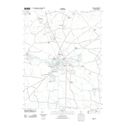
2011 Map of Laurel
USGS Topo · Published 2011About this map
Broad Creek flows westward through the heart of this Sussex County landscape, anchoring the historic town of Laurel and the neighboring community of Bethel. This 2011 survey reveals a complex network of residential developments and rural outposts, where named areas like Woodland Heights, Lakeside Manor, and Colonial Acres speak to the region's 21st-century growth. The map provides significant detail for genealogists, identifying numerous burial grounds such as Laurel Hill Cemetery, the Odd Fellows Cemetery, and the New Mount Zion Methodist Cemetery. The water-based infrastructure of the area is well-documented, featuring the Records Pond Dam and Chipman Pond Dam, along with numerous named branches like the Rossakatum Branch and James Branch that drain the low-lying terrain. From the Laurel Airport to the Shell Bridge, the map illustrates a landscape where modern aviation and housing developments coexist with traditional crossroads like Hearns Crossroads and Bacons.
Find a feature on this map
130 named features on this map. Tap any name to fly to it.
Don’t see what you’re looking for? This feature index may not catch every label — zoom into the map to look around manually.
Map Details
Editions of this 2011 Laurel Map
This is the sole edition of this map. No revisions or reprints were ever made.
Other maps of this area

1901 · Salisbury
USGS Topo · 1:62,500

1902 · Pittsville
USGS Topo · 1:62,500

1915 · Seaford
USGS Topo · 1:62,500

1917 · Millsboro
USGS Topo · 1:62,500

1938 · Millsboro
USGS Topo · 1:62,500

1942 · Hebron
USGS Topo · 1:24,000

1942 · Delmar
USGS Topo · 1:24,000

1942 · Pittsville
USGS Topo · 1:24,000
1943 · Delmar
USGS Topo · 1:31,680

1943 · Hebron
USGS Topo · 1:31,680