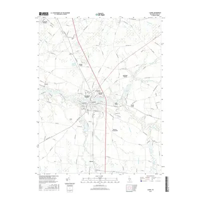
2016 Map of Laurel
USGS Topo · Published 2016About this map
Laurel serves as the focal point of this Delaware landscape, positioned where Broad Creek transitions into Records Pond. The town's historical depth is reflected in its concentrated burial grounds, including the Laurel Hill Cem and Odd Fellows Cem. Beyond the town center, the terrain is defined by a dense network of slow-moving waterways such as Rossakatum Br and Tussocky Br, which drain the low-lying coastal plain into the Nanticoke River at the western edge of the survey. The mapping reveals a transition from the established residential pockets of Lakeside Manor to the more rural, named intersections like Hearns Crossroads and Bacons. Interesting local nomenclature like Midnight Thicket and Bulkhead Shoal Channel suggests the specific character of the surrounding woods and waters, while the presence of the Laurel Airport marks the modern utility of these wide coastal reaches.
Find a feature on this map
164 named features on this map. Tap any name to fly to it.
Don’t see what you’re looking for? This feature index may not catch every label — zoom into the map to look around manually.
Map Details
Editions of this 2016 Laurel Map
This is the sole edition of this map. No revisions or reprints were ever made.
Other maps of this area

1901 · Salisbury
USGS Topo · 1:62,500

1902 · Pittsville
USGS Topo · 1:62,500

1915 · Seaford
USGS Topo · 1:62,500

1917 · Millsboro
USGS Topo · 1:62,500

1938 · Millsboro
USGS Topo · 1:62,500

1942 · Hebron
USGS Topo · 1:24,000

1942 · Delmar
USGS Topo · 1:24,000

1942 · Pittsville
USGS Topo · 1:24,000
1943 · Delmar
USGS Topo · 1:31,680

1943 · Hebron
USGS Topo · 1:31,680