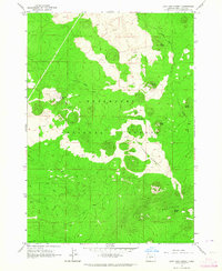
1963 Map of Lava Cast Forest
USGS Topo · Published 1964About this map
The Lava Cast Forest dominates this volcanic landscape in central Oregon, showing where ancient lava flows once enveloped a standing forest, leaving behind the distinctive tree molds from which it takes its name. Situated within the Deschutes National Forest, the terrain is defined by its dramatic geologic features and varying elevations, ranging from the cinder cones of Sugar Pine Butte and Mokst Butte to the higher reaches of the Paulina Mountains in the south.
Find a feature on this map
12 named features on this map. Tap any name to fly to it.
Don’t see what you’re looking for? This feature index may not catch every label — zoom into the map to look around manually.
Map Details
Editions of this 1963 Lava Cast Forest Map
3 editions found
Other maps of this area

1931 · Newberry Crater
USGS Topo · 1:125,000

1935 · Newberry Crater
USGS Topo · 1:125,000

1955 · Crescent
USGS Topo · 1:250,000

1957 · Crescent
USGS Topo · 1:250,000

1958 · Crescent
USGS Topo · 1:250,000
1963 · Lava Butte
USGS Topo · 1:24,000
1963 · Benham Falls
USGS Topo · 1:24,000
1963 · Anns Butte
USGS Topo · 1:24,000
1963 · Finley Butte
USGS Topo · 1:24,000
1963 · Paulina Peak
USGS Topo · 1:24,000