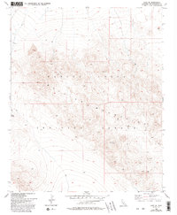
1955 Map of Lavic SE
USGS Topo · Published 1993About this map
The Bullion Mountains dominate this high-desert landscape in San Bernardino County, where the terrain is defined by volcanic features and significant military activity. As of this 1955 survey, the area is incorporated into the Marine Corps Training Center, reflecting the mid-century expansion of military training grounds in the California desert. Significant topographical landmarks include the basaltic flows of Lava in the northwest and distinctive survey points such as VABM 2813 Mesa and VABM 4699 Round. Movement through this high-elevation corridor is limited to primitive 4wd tracks, including the route navigating Gays Pass. The map reveals a land utilized almost exclusively for large-scale maneuvers and geological study, with no permanent civilian settlements or public infrastructure present within the mountain range.
Find a feature on this map
8 named features on this map. Tap any name to fly to it.
Don’t see what you’re looking for? This feature index may not catch every label — zoom into the map to look around manually.
Map Details
Editions of this 1955 Lavic SE Map
5 editions found
Other maps of this area

1953 · San Bernardino
USGS Topo · 1:250,000

1954 · Galway Lake
USGS Topo · 1:24,000

1954 · Hidalgo Mtn
USGS Topo · 1:24,000

1954 · Emerson Lake
USGS Topo · 1:24,000

1955 · Deadman Lake NW
USGS Topo · 1:24,000

1955 · Ludlow
USGS Topo · 1:24,000

1955 · Lavic SE
USGS Topo · 1:24,000

1955 · Morgans Well
USGS Topo · 1:24,000

1955 · Sunshine Peak
USGS Topo · 1:24,000

1955 · Lavic Lake
USGS Topo · 1:24,000