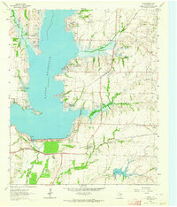
1963 Map of Lavon
USGS Topo · Published 1964About this map
Lavon Reservoir dominates the landscape of southern Collin County in the early 1960s, its shoreline shaped by numerous new residential developments including Lavon Beach Estates, Yucote Acres, and Deep Water Point Estates. The map illustrates the transition from a traditional rail-and-river economy to a water-recreation and suburban hub. Transportation is defined by the St Louis Southwestern and the Gulf Colorado and Santa Fe railroads, which cross the terrain near the massive Lavon Dam. Historic rural infrastructure remains visible through numerous family and community landmarks such as Smith Cem, Shiloh Cem, and Bear Creek Cem. Industrial activity is represented by several Quarries and a Quarry located near the established town site of Lavon.
Find a feature on this map
42 named features on this map. Tap any name to fly to it.
Don’t see what you’re looking for? This feature index may not catch every label — zoom into the map to look around manually.
Map Details
Editions of this 1963 Lavon Map
Other maps of this area

1891 · Dallas
USGS Topo · 1:125,000

1893 · Dallas
USGS Topo · 1:125,000

1912 · Rockwall
USGS Topo · 1:31,680

1919 · Royse City
USGS Topo · 1:62,500

1924 · Farmersville 3-c
USGS Topo · 1:48,000

1924 · Mc Kinney 4-d
USGS Topo · 1:48,000

1929 · McKinney
USGS Topo · 1:62,500

1930 · Farmersville
USGS Topo · 1:62,500

1954 · Dallas
USGS Topo · 1:250,000

1954 · Sherman
USGS Topo · 1:250,000