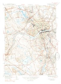
1944 Map of Lawrence
USGS Topo · Published 1947About this map
The Merrimack River bisects this mid-1940s landscape, serving as the industrial and geographic anchor for the densely developed city of Lawrence. This survey captures the urban core during a period of significant density, showing the tight grid of the Court House district and the expansive Boston and Maine Railroad network that fueled the region's textile era. To the north, Methuen transitions from town streets to the hills of Meetinghouse Hill and Daddy Frye Hill, while south across the river, the planned character of Shawsheen Village and the academic grounds of Phillips Academy in Andover contrast with the industrial riverfront. This map is particularly valuable for its density of civic institutions, from the St Francis Seminary to the Radio Sta Wlaw, alongside a sprawling collection of ethnic and religious burial grounds including Lithuanian Cem, Polish Cem, and Sts Peter & Paul Cem.
Find a feature on this map
101 named features on this map. Tap any name to fly to it.
Don’t see what you’re looking for? This feature index may not catch every label — zoom into the map to look around manually.
Map Details
Editions of this 1944 Lawrence Map
4 editions found
Other maps of this area

1886 · Lawrence
USGS Topo · 1:62,500

1886 · Lowell
USGS Topo · 1:62,500

1888 · Haverhill
USGS Topo · 1:62,500

1888 · Lawrence
USGS Topo · 1:62,500

1890 · Haverhill
USGS Topo · 1:62,500

1893 · Lowell
USGS Topo · 1:62,500

1893 · Lawrence
USGS Topo · 1:62,500

1893 · Haverhill
USGS Topo · 1:62,500

1905 · Manchester
USGS Topo · 1:62,500

1918 · Lowell
USGS Topo · 1:62,500