1983 Map of Lawrence
USGS Topo · Published 1984About this map
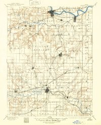
Topeka and Ottawa anchor this early 1980s landscape, a region defined by the convergence of major water projects and historic transportation corridors. The introduction of large reservoirs like Clinton Lake, Pomona Lake, and Melvern Lake transformed the hydrology of the Wakarusa River and Marais des Cygnes River basins, creating substantial recreation areas such as Clinton State Park and Melvern State Park. These man-made features overlay an older infrastructure of rail lines including the Atchison Topeka and Santa Fe and Union Pacific, which connect established settlements like Carbondale, Osage City, and Wellsville. The presence of Forbes Field and various municipal airports reflects the post-war aviation growth near the state capital. For local historians, the map details the rural fabric between these hubs, from the Highland Cem to the numerous creeks and hills like Blue Mound that have guided travel for generations.
Find a feature on this map
99 named features on this map. Tap any name to fly to it.
Don’t see what you’re looking for? This feature index may not catch every label — zoom into the map to look around manually.
Map Details
Editions of this 1983 Lawrence Map
This is the sole edition of this map. No revisions or reprints were ever made.
Historical Maps of Topeka Through Time
7 maps found