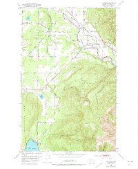
1952 Map of Lawrence
USGS Topo · Published 1974About this map
The Nooksack River winds through this Northwest Washington landscape, anchoring a corridor of small riverside and rail-adjacent settlements. Several communities appear as distinct hubs of activity, including Lawrence, Goshen, Cedarville, and North Cedarville. The influence of early transportation is evident in the path of the Chicago Milwaukee St Paul and Pacific railroad and the presence of an Old Railroad Grade. To the south, the northern tip of Lake Whatcom meets the shore at Agate Bay, while the northern terrain is dominated by the steep slopes of Sumas Mt N. This 1952 field-checked record, later updated with 1970s aerial data, provides a detailed view of the rural infrastructure between the mountains and the water, showing the Grange Hall and numerous family-named roads like George Road and Roberts Road that connected these timber and farming communities.
Find a feature on this map
49 named features on this map. Tap any name to fly to it.
Don’t see what you’re looking for? This feature index may not catch every label — zoom into the map to look around manually.
Map Details
Editions of this 1952 Lawrence Map
4 editions found
Other maps of this area

1906 · Sumas
USGS Topo · 1:62,500

1908 · Sumas
USGS Topo · 1:62,500

1918 · Samish Lake
USGS Topo · 1:62,500

1919 · Van Zandt
USGS Topo · 1:62,500

1921 · Wickersham
USGS Topo · 1:62,500

1951 · Wickersham
USGS Topo · 1:62,500

1951 · Van Zandt
USGS Topo · 1:62,500

1952 · Lake Whatcom
USGS Topo · 1:24,000

1952 · Lynden
USGS Topo · 1:24,000

1952 · Lawrence
USGS Topo · 1:24,000