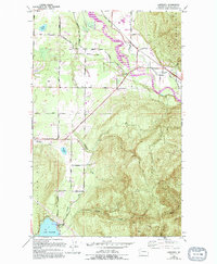
1952 Map of Lawrence
USGS Topo · Published 1994About this map
The Nooksack River valley carves through the landscape of Whatcom County, flanked by the prominent elevations of Sumas Mountain and Squalicum Mountain. This 1952 survey, updated with late-century revisions, documents the early rural settlements of Lawrence, Goshen, and Cedarville as they were situated along the floodplain. The area's industrial and logging history is evidenced by an Old Railroad Grade and designated logging grounds near the river, while the presence of several gravel pits points to the local extraction economy.
Find a feature on this map
49 named features on this map. Tap any name to fly to it.
Don’t see what you’re looking for? This feature index may not catch every label — zoom into the map to look around manually.
Map Details
Editions of this 1952 Lawrence Map
4 editions found
Other maps of this area

1906 · Sumas
USGS Topo · 1:62,500

1908 · Sumas
USGS Topo · 1:62,500

1918 · Samish Lake
USGS Topo · 1:62,500

1919 · Van Zandt
USGS Topo · 1:62,500

1921 · Wickersham
USGS Topo · 1:62,500

1951 · Wickersham
USGS Topo · 1:62,500

1951 · Van Zandt
USGS Topo · 1:62,500

1952 · Lake Whatcom
USGS Topo · 1:24,000

1952 · Lynden
USGS Topo · 1:24,000

1952 · Lawrence
USGS Topo · 1:24,000