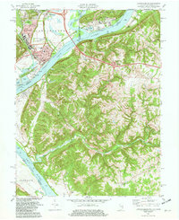
1981 Map of Lawrenceburg
USGS Topo · Published 1982About this map
The Ohio River valley serves as the central artery for this tri-state junction where Indiana, Kentucky, and Ohio converge. Lawrenceburg and Greendale dominate the Indiana bank, showcasing a dense network of transit infrastructure including the Baltimore and Ohio and Conrail lines. Across the water in Kentucky, the terrain transitions into the steep drainages of Woolper Creek and Garrison Creek, where smaller settlements like Petersburg and Idlewild reflect a more rural character. Genealogists will find a wealth of data points across the landscape, from the large Greendale Cem to family-named burial grounds such as Dinsmore Cem and Tousey Cem. Significant industrial and public landmarks are clearly marked, including the Powerplant near Finney and the Courthouse in the heart of Lawrenceburg, documenting the civic and economic hubs of the early 1980s.
Find a feature on this map
59 named features on this map. Tap any name to fly to it.
Don’t see what you’re looking for? This feature index may not catch every label — zoom into the map to look around manually.
Map Details
Editions of this 1981 Lawrenceburg Map
3 editions found
Other maps of this area

1914 · West Cincinnati
USGS Topo · 1:62,500

1915 · Lawrenceburg
USGS Topo · 1:48,000

1928 · Lawrenceburg
USGS Topo · 1:62,500

1932 · Lawrenceburg
USGS Topo · 1:62,500

1943 · Aberdeen
USGS Topo · 1:24,000

1943 · Aurora
USGS Topo · 1:24,000

1943 · Rising Sun
USGS Topo · 1:24,000

1943 · Hooven
USGS Topo · 1:24,000

1943 · Guilford
USGS Topo · 1:24,000

1943 · Lawrenceburg
USGS Topo · 1:24,000