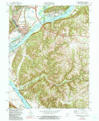
1981 Map of Lawrenceburg
USGS Topo · Published 1991About this map
Lawrenceburg and its neighboring communities of Greendale and Aurora sit at a strategic tri-state junction where the Great Miami River and Tanners Creek join the Ohio River. This 1980s landscape shows the heavy infrastructure of the river-and-rail economy, with both the Baltimore and Ohio and Conrail railroads threading through the valley alongside a massive powerplant and industrial settling ponds. North of the urban center, the Fairgrounds and various cemeteries like Greendale Cem mark the established local culture of Dearborn County. Across the river in Kentucky, the terrain transitions into the steep, winding valleys of Woolper Creek and Garrison Creek, where family-named landmarks such as Dinsmore Cem and Bullittsburg Ch reflect a more rural, dispersed settlement pattern near the Boone County line.
Find a feature on this map
89 named features on this map. Tap any name to fly to it.
Don’t see what you’re looking for? This feature index may not catch every label — zoom into the map to look around manually.
Map Details
Editions of this 1981 Lawrenceburg Map
3 editions found
Other maps of this area

1914 · West Cincinnati
USGS Topo · 1:62,500

1915 · Lawrenceburg
USGS Topo · 1:48,000

1928 · Lawrenceburg
USGS Topo · 1:62,500

1932 · Lawrenceburg
USGS Topo · 1:62,500

1943 · Aberdeen
USGS Topo · 1:24,000

1943 · Aurora
USGS Topo · 1:24,000

1943 · Rising Sun
USGS Topo · 1:24,000

1943 · Hooven
USGS Topo · 1:24,000

1943 · Guilford
USGS Topo · 1:24,000

1943 · Lawrenceburg
USGS Topo · 1:24,000