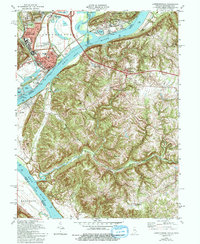
1981 Map of Lawrenceburg
USGS Topo · Published 1994About this map
The Ohio River serves as the central artery for this tri-state junction, where Indiana, Kentucky, and Ohio converge. Industrial and transportation infrastructure dominates the landscape near Lawrenceburg, with the Conrail and Baltimore and Ohio RR lines threading through the river valley alongside a large powerplant and sewage disposal facilities. This 1980s snapshot records the urban core of Greendale and Lawrenceburg, featuring civic landmarks like the Courthouse and Library, while the surrounding hills remain dotted with small family burial grounds and rural communities.
Find a feature on this map
57 named features on this map. Tap any name to fly to it.
Don’t see what you’re looking for? This feature index may not catch every label — zoom into the map to look around manually.
Map Details
Editions of this 1981 Lawrenceburg Map
3 editions found
Other maps of this area

1914 · West Cincinnati
USGS Topo · 1:62,500

1915 · Lawrenceburg
USGS Topo · 1:48,000

1928 · Lawrenceburg
USGS Topo · 1:62,500

1932 · Lawrenceburg
USGS Topo · 1:62,500

1943 · Aberdeen
USGS Topo · 1:24,000

1943 · Aurora
USGS Topo · 1:24,000

1943 · Rising Sun
USGS Topo · 1:24,000

1943 · Hooven
USGS Topo · 1:24,000

1943 · Guilford
USGS Topo · 1:24,000

1943 · Lawrenceburg
USGS Topo · 1:24,000