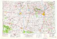
1955 Map of Lawton
USGS Topo · Published 1976About this map
Wichita Mountains National Wildlife Refuge and the adjacent Fort Sill Military Reservation dominate the central landscape of this southwestern Oklahoma survey. The terrain transitions from the jagged peaks of Mount Scott and the Navajo Mountains to the expansive river basins of the Red River and North Fork Red River. Regional centers like Lawton, Altus, and Frederick serve as hubs for a dense network of transit, including the St Louis-San Francisco Ry and the Chicago Rock Island and Pacific RR. The map illustrates a mid-century period of water management and infrastructure growth, shown by the footprints of Lake Lawtonka, Lake Ellsworth, and the Tom Steed Reservoir. To the west and south, the Texas-Oklahoma State Line divides the territory near Hollis and Quanah, where the Pease River and Wichita River flow through the plains of Hardeman County and Wichita County.
Find a feature on this map
132 named features on this map. Tap any name to fly to it.
Don’t see what you’re looking for? This feature index may not catch every label — zoom into the map to look around manually.
Map Details
Editions of this 1955 Lawton Map
5 editions found

Other maps of this area

1901 · Addington
USGS Topo · 1:125,000

1902 · Rush Springs
USGS Topo · 1:125,000

1904 · Chickasha
USGS Topo · 1:125,000

1905 · Montague
USGS Topo · 1:125,000

1915 · Clara
USGS Topo · 1:24,000

1915 · Barwise School
USGS Topo · 1:24,000

1915 · Burkburnett
USGS Topo · 1:24,000

1916 · Electra
USGS Topo · 1:24,000

1916 · Iowa Park
USGS Topo · 1:24,000

1916 · Fowlkes
USGS Topo · 1:24,000