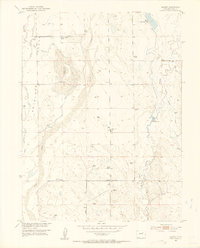
1951 Map of Leader
USGS Topo · Published 1953About this map
Leader School and the nearby Leader Community Hall serve as the focal points for this rural Adams County landscape during the early 1950s. The map illustrates a reliance on water management and aerial navigation, featuring an Airway Beacon and a series of reservoirs including Moore Reservoir No 4 and Moore Reservoir No 1. The presence of the Nile Reservoir (Abandoned) and Plainview Sch (Abandoned) suggests shifting settlement patterns and land use in this section of the Missouri River Basin.
Find a feature on this map
16 named features on this map. Tap any name to fly to it.
Don’t see what you’re looking for? This feature index may not catch every label — zoom into the map to look around manually.
Map Details
Editions of this 1951 Leader Map
5 editions found
Other maps of this area

1950 · Wiggins SW
USGS Topo · 1:24,000

1950 · Hoyt
USGS Topo · 1:24,000

1951 · Hoyt
USGS Topo · 1:24,000

1951 · Leader NW
USGS Topo · 1:24,000

1951 · Leader SE
USGS Topo · 1:24,000

1951 · Leader
USGS Topo · 1:24,000

1952 · Leader SW
USGS Topo · 1:24,000

1953 · Denver
USGS Topo · 1:250,000

1954 · Limon
USGS Topo · 1:250,000

1954 · Sterling
USGS Topo · 1:250,000