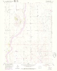
1951 Map of Leader
USGS Topo · Published 1979About this map
Bijou Creek and Muddy Creek dominate the drainage patterns of this Adams County landscape, where the agricultural economy of the mid-20th century is clearly defined by scattered water infrastructure. The map reveals a transition in local land use, notably marking the Nile Reservoir (Abandoned) and associated dry works like the Nile Inlet Ditch (Aban'd). These features, alongside Nile Flats, suggest an era of intensive water management that had already begun to shift by the time of the 1951 survey.
Find a feature on this map
20 named features on this map. Tap any name to fly to it.
Don’t see what you’re looking for? This feature index may not catch every label — zoom into the map to look around manually.
Map Details
Editions of this 1951 Leader Map
5 editions found
Other maps of this area

1950 · Wiggins SW
USGS Topo · 1:24,000

1950 · Hoyt
USGS Topo · 1:24,000

1951 · Hoyt
USGS Topo · 1:24,000

1951 · Leader NW
USGS Topo · 1:24,000

1951 · Leader SE
USGS Topo · 1:24,000

1951 · Leader
USGS Topo · 1:24,000

1952 · Leader SW
USGS Topo · 1:24,000

1953 · Denver
USGS Topo · 1:250,000

1954 · Limon
USGS Topo · 1:250,000

1954 · Sterling
USGS Topo · 1:250,000