1970 Map of Leadville North
USGS Topo · Published 1973About this map
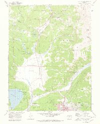
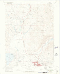
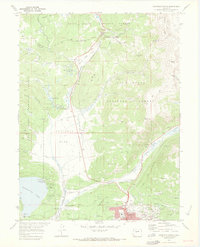
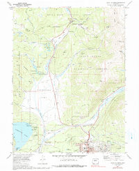
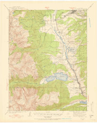
Leadville and its northern mining districts dominate this 1970 survey, revealing the industrial and recreational character of the High Rockies. The northern edge of the city shows the West Park Sch and Evergreen Cem, while the legendary mining history of the region is grounded in labels like the Matchless Mine on Fryer Hill and the Jennie June Mine. The landscape is defined by the Continental Divide, which separates the headwaters of the Arkansas River from the Tennessee Creek drainage. Transportation infrastructure is anchored by the Denver and Rio Grande Western Railroad winding through Tennessee Pass. To the west, the Sugarloaf Dam contains Turquoise Lake, where campgrounds like Molly Brown Campground reflect the era's growing focus on forest-based recreation within the San Isabel National Forest.
Find a feature on this map
60 named features on this map. Tap any name to fly to it.
Don’t see what you’re looking for? This feature index may not catch every label — zoom into the map to look around manually.
Map Details
Editions of this 1970 Leadville North Map
4 editions found
Other maps of this area

1889 · Leadville
USGS Topo · 1:125,000

1891 · Leadville
USGS Topo · 1:125,000

1934 · Climax
USGS Topo · 1:48,000
1935 · Mount Elbert
USGS Topo · 1:62,500
1938 · Mt. Lincoln
USGS Topo · 1:48,000

1938 · Mount Elbert
USGS Topo · 1:62,500

1939 · Mount Elbert
USGS Topo · 1:62,500

1942 · Leadville
USGS Topo · 1:125,000
1945 · Mount Lincoln
USGS Topo · 1:62,500
1949 · Holy Cross
USGS Topo · 1:62,500